GIS24.net
Geographic Information System
POI database from MEINWOMOmaps


Geographic Information System
POI database from MEINWOMOmaps
Krämerod 765 m
Alpine / mountaintop
ADDRESS
Click for interactive map
..
Pictures of the Poi and surroundings
.
Things to see in the area
Gabelskopf
743 m Thuringian Forest[ click for more information ]
Sperrhügel
Thuringian Forest, 882 m[ click for more information ]
Wasserfall
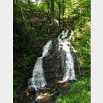 Spitterfall, the largest natural waterfall in the Thuringian Forest
[ click for more information ]
Via Porta VI, Ebertswiese - Suhler Hütte
Ecumenical pilgrimage route from the Volkenroda monastery to the Waldsassen monastery Stage VI Ebertswiese - Suhler Hütte This stage runs entirely on the Rennsteigweg through a beautiful mountain landscape.[ click for more information ]
Rennsteig-Leiter Floh-Seligenthal-Schmalkalden,
Connecting path to the Rennsteigweg.[ click for more information ]
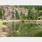 Bergsee Waldsee mit Bademöglichkeit (auf eigene Gefahr)
[ click for more information ]
Tages Wanderparkplatz
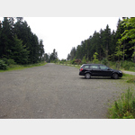 A large hiking car park near the mountain lake and the Ebertswiese with many hiking opportunities can only be reached via a paved forest path.
 [ click for more information ]
Mittlerer Höhenberg
Thuringian Forest, 835 m[ click for more information ]
Oberlaudenberg
Thuringian Forest, 856 m[ click for more information ]
Freibad
Forest swimming pool Aquarius Georgenthal[ click for more information ]
Schule
Elementary school Am Rennsteig Tambach-Dietharz[ click for more information ]
Georgenthal
Tambach-Dietharz Lutheran Church[ click for more information ]
Hellenberg
Thuringian Forest, 799 m[ click for more information ]
Rennsteig-Leiter Oberschönau
Connecting path to the Rennsteigweg.[ click for more information ]